

Sudbury Basin · Ontario, Canada
Brady Sudbury Project
Surrounded by Sudbury's Giants
World-Class Neighbourhood
The 8,811-hectare Brady Project sits on the northeast flank of the Sudbury Basin — near Vale, Glencore and Magna Mining operations, including their 37 Mt (Inferred) Norman West Ni-Cu deposit.† The Brady Sudbury Project lies in close proximity to some of the Sudbury Basin's most significant Ni-Cu-PGM and gold producers.*
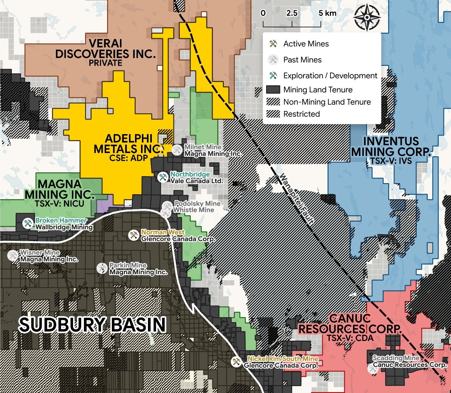 The Brady Sudbury Project within the Sudbury Basin and its neighbouring deposits
Norman West Deposit
37 Mt (Inferred) Ni-Cu-PGM deposit neighbouring the south boundary.†
Podolsky Mine
Home to the 'Yellow Brick Road' — one of Sudbury's highest-grade copper footwall zones.
Whistle & Northbridge
Past producers along the 'Nickel Road' — Brady's access corridor.
*Mineralization on neighbouring or adjacent properties is not necessarily indicative of mineralization on the Brady Project. †Norman West Deposit: 37 Mt Inferred (Geology Ontario, MDI000000003067).
The Driver
A Fault-Controlled Mineral System
The Wanapitei Fault runs the length of the property and projects south into the Scadding gold deposit — a past producer interpreted as an IOCG-style system. Adelphi interprets this fault as the driver of a MIAC mineral system, the structure controlling the gold-copper showings as surface expressions of one fault-driven system.
The Mechanism · One System
-
1
The Fault
The Wanapitei Fault is the master structure, controlling mineralization along its length.
-
2
The Splays
Structures branch off the fault, channelling metals along geological contacts into the surrounding rock (Gold / Copper Showings).
-
3
The Comparable
The Scadding Deposit sits on the same structure to the south — an IOCG-style system in a comparable geological setting.
-
The Opportunity
A coherent mineral system where the biggest target has never been tested.
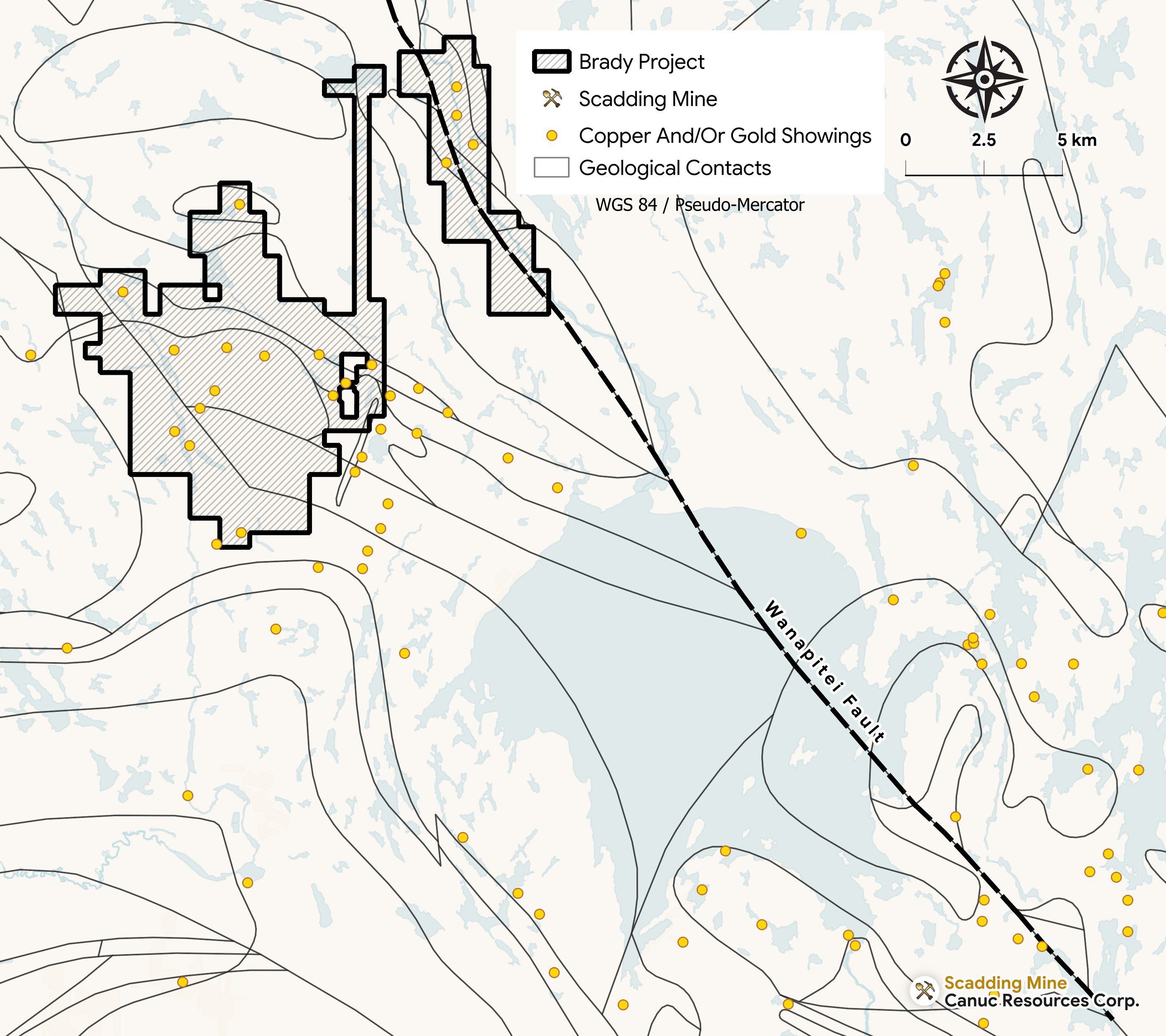 The Wanapitei Fault, projecting south into the Scadding Mine
Exploration Targets
Showings Across the System
River North Target
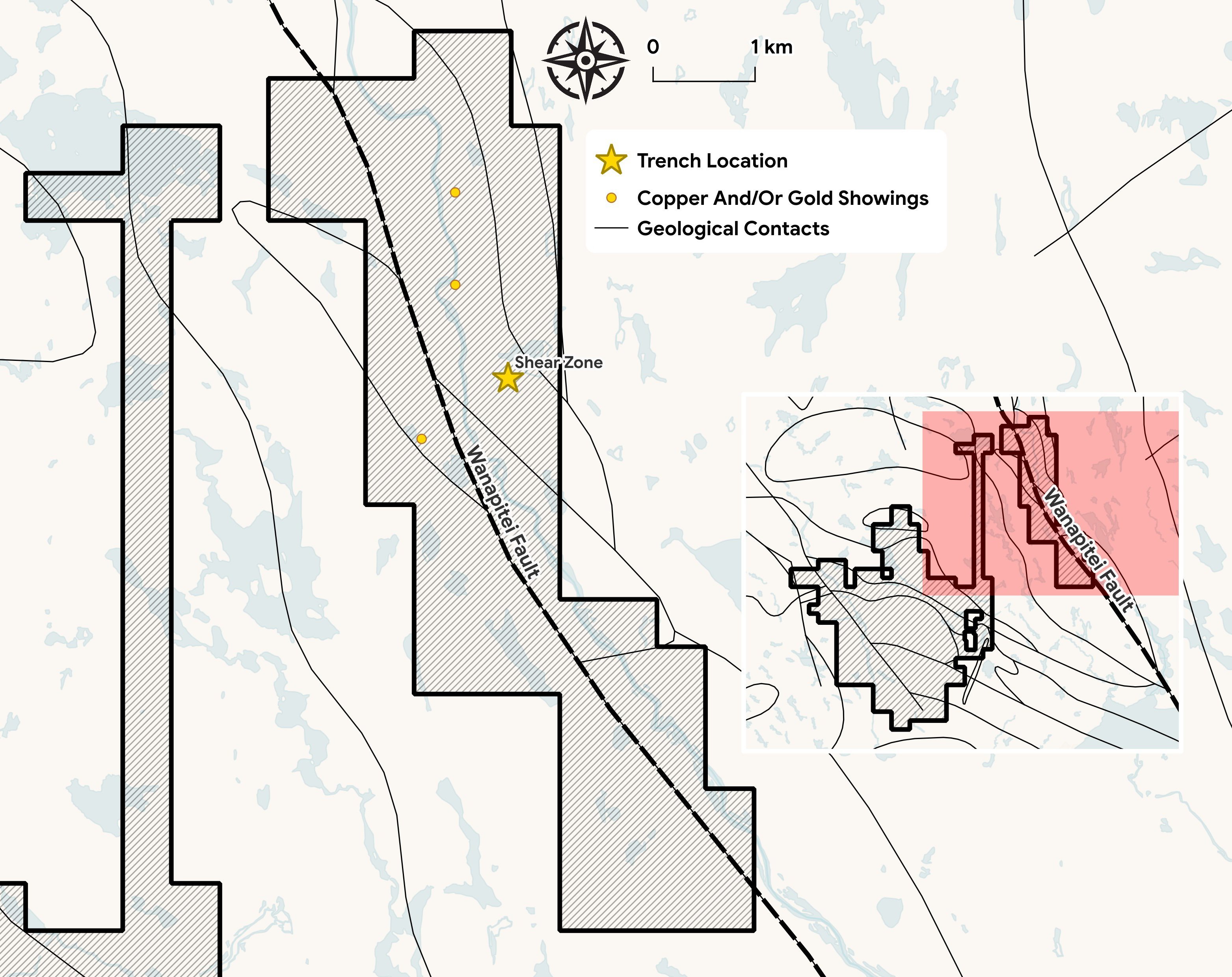
A 6 m shear zone — the Malachite Showing — sits directly on the Wanapitei Fault, where the 2023 trench ended before the mineralization did.
- Iron-rich throughout — Fe to 9.9%, with 2,000–10,000 ppm Cu and 0.5–3 g/t Au. A planned ground gravity survey will test for an iron-rich, IOCG-style body at depth.
- Interpreted as the same structure as the Scadding Deposit — the Wanapitei Fault projects south along the same corridor into Scadding, an IOCG-style past producer.
- No modern drilling has ever been completed on the property.
Gold on the Contact
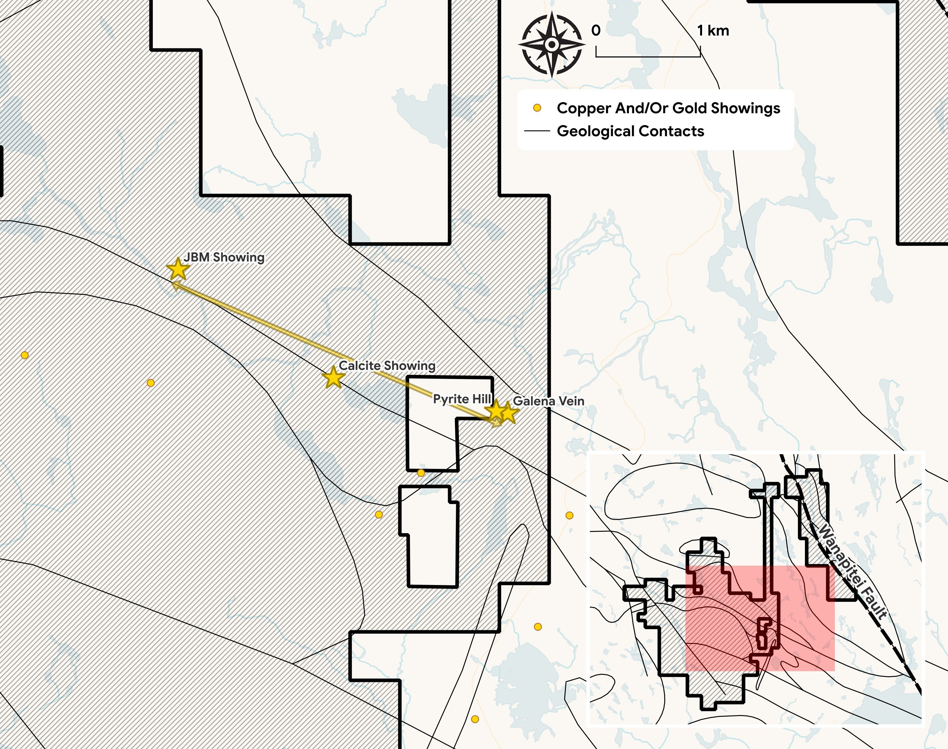
Four gold-copper-silver showings (Pyrite Hill/Galena, Calcite, JBM, McFie Lake) align along a 6 km NW corridor. A continuous 4 km IP chargeability anomaly links them, is open in both directions, and has never been drilled. At the marble quarry, magnetite-albite alteration is consistent with a MIAC system — the property's most direct physical evidence.
Pyrite Hill / Galena
High-grade gold at surface, directly over the untested IP anomaly on the contact. Select surface grab: 16.85 g/t Au, 28.8 g/t Ag, 0.59% Cu — with tellurium, a gold-system pathfinder, confirmed at surface.
The Same System, Stepped Out
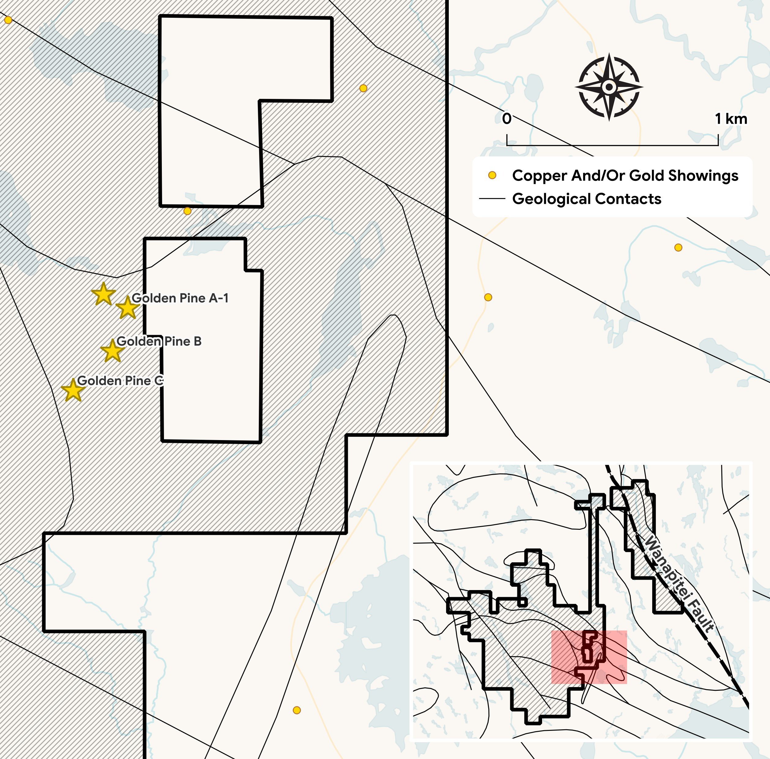
We interpret Golden Pine as the same gold system, stepped out along another splay of the Wanapitei structure — high-grade, and untested at depth.
- A ~150 m wide shear system in altered mafic to felsic volcanics with up to 40% disseminated pyrite — four mineralized zones, none drilled out.
- A 1 km IP anomaly extension to the northeast has never been drill-tested.
- Prior drilling was incorrectly positioned relative to the zones — the targets remain open.
Exploration Path
Vectoring to Drill Targets
Our program is sequenced to confirm the fault-driven system and convert it into drill-ready targets. Field crews are on the ground as of summer 2026, with geophysical surveys to be completed in the coming months, designed to generate steady updates toward a maiden drill program.
Confirm the System
- Ground sampling and structural mapping along the Wanapitei corridor and Marble Mountain contact — field crews are now on the property.
- Ground gravity at North River to test for an iron-rich body at depth.
- VTEM over Marble Mountain to define conductors beneath the IP anomaly.
Define the Targets
- 3D inversion of existing IP, with infill lines to close coverage gaps.
- Channel sampling along the limestone contact, Pyrite Hill to Calcite.
- Integrate sampling, gravity, VTEM and IP into ranked, drill-ready targets.
Maiden Drill Program
- Integrate all sampling, geophysics and structural data collected to date into a ranked target list.
- Plan and permit a maiden drill program at the highest-priority targets defined by the work.